

Date: 3rd March 2024
Start: Beach Road Holiday Park, Oreti Beach (km 2987.7)
End: Stirling Point (km 3028.9)
Distance Travelled: 41.2 km
Total Distance Completed: 2879.2 km
Song Currently Stuck in Head: Praise You by Fatboy Slim (“we’ve come a long long way together, through the hard times and the good”)
Emotions: elation, relief, satisfaction, and a hint of sadness
Here’s something I thought I’d never say: thank goodness it’s raining so I don’t have to pack up my tent. It began right on the stroke of 6am, meaning that I wouldn’t be forced to try and catch up with Matt and Melly this morning, they could leave at the same time as me. I’d also like to say that I did an immaculate job at blowing up my air mattress last night. It has never felt firmer throughout the entire trail than it did last night.
I wasn’t fully prevented from leaving before sunrise, but there was at least some light in the sky when we broke camp for the last time and stepped foot onto the road.

Starting off today would just be the original three. Oli wanted to run to Bluff, just because. Sean, yet again, was being an absolute angel and agreed to take his pack. The three of us made bets on when Oli would catch up with us. None of us came close thanks to Oli sleeping in, eventually reuniting (briefly) around 8:45. He sped off, leaving the three of us on a lovely gravel cycleway next to an estuary.

It was along this path that we passed the 3000 km mark, the nominal distance of the TA. The last time it was exactly 3000 km was back in 2019, I believe. Alterations and detours have increased the distance by a further 29 km, so I guess I’ll have to keep walking.
The walkway intersects with SH1 south of Invercargill, joining with a new cycleway all the way to the outskirts of Bluff. I assumed the path would be nicely separated from the highway, but in many cases it was just a bit of additional asphalt added on the side that didn’t even have a barrier to protect the soft squishy walkers and cyclists from the hard metal cars and trucks. Still a degree better than having to walk on the actual road shoulder, especially with the amount of traffic coming through on a Sunday. Seriously, what is there to do in Bluff on a Sunday?
Motivated to finish this part of the trail as quickly as I could, I kicked it up a gear for a while until running into Sean and Oli sitting in a grassy field off the highway waiting for us to arrive for lunch. With what I presume is the same frying pan that made me irrationally mad on the Whanganui River, he cooked up some hot dogs and burgers for us, our final lunch on trail. They went down a treat.
Back on the track, a short section led away from the highway and down a gravel access road. It was here that we met a very friendly goat sitting in a grassy field that presumably he was tasked with mowing. He approached us as we neared his A frame shelter and offered himself for pats which we were happy to oblige with. This was clearly a sneaky trick as his, er, scent was then transferred onto our hands and remained there for the rest of the day.

Back on the road, the industrial areas of Bluff came into view. I really could’ve made that sentence more concise and just said “Bluff came into view” because Bluff is all industry. It’s a small port town that transports… honestly I’m not sure, all I could see were piles of some generic bulk good and a solitary ship loading some of it.

Then a rather odd sight greeted me on the other side of the highway. I saw an old Brisbane train carriage used in the days before our suburban network was electrified. Why it’s in Bluff I’ll likely never know.

Our final road walk ended at the entrance to Bluff where a rusty sign has been erected that no, they’re not bluffing, you’re in Bluff. From the sign we leave the road and hesd along the Foveaux Walkway that follows the coast around Bluff Hill. Not before having a lengthy photoshoot in front of the sign, of course. That’s what I get for following two photographers for over 3 months.

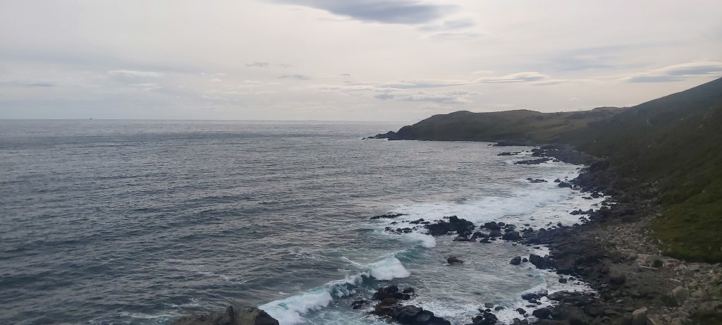
Now this is the ending I was looking for. The coast around Bluff has a very wild feel to it. Even on a good day like today there were large waves battering the jagged rocks beneath us. It was beautiful. Don’t think I’d be using that word if I was on the strait itself, mind you. Whenever I get across to Stewart Island I think I’ll probably fly there.

The path was easy to follow and well marked and it didn’t take us long to reach a lookout where we got an excellent view of Stewart Island. There’s plenty of good walking over there, including an easy Great Walk and a ridiculously muddy circuit around the entire island. After Te Araroa I don’t think I’d find it any more difficult than what I’ve already done, but I’ve had enough of mud for now. Maybe someday in the future when all memory of the Dome Forest, Mt Pirongia, the Tararuas, and Longwood Forest has passed by, only then will I be ready to hurt myself again.

In years past, Te Araroa at this point used to continue on the Foveaux Walkway around the bottom of Bluff Hill to Stirling Point. Somewhere in the last couple years, whether due to track damage or the TA Trust wanting to troll us hikers one last time, the trail was re-routed up and over Bluff Hill for one final climb. Sure, it’s only 240 m of ascent, but it could’ve been zero. To rub salt into the wound, there’s no view from the top, everything’s covered in trees. At least the path is in good nick.
There was now only 2 km to go, one final descent. We dropped into a small forest, listening to the sounds of tui, piwakawaka, and kereru. Despite the terminus being a stone’s throw away, I actually slowed down and just soaked in the forest. I’m gonna miss these sounds and sights. I hope it doesn’t come as a surprise that I love birds and is one of the main reasons I like to go hiking in New Zealand.
The final kilometre went past a bunch of old concrete foundations that held coastal fortifications and guns during the Second World War. Beats me why anyone would want to invade Bluff, maybe New Zealand’s military commanders back then knew something I don’t. Then, with 200 m to go, the yellow signpost was spotted… surrounded by a bus load of, ugh, tourists. So guess what? We waited for them to leave. 10 minutes later they were gone. Descending down the few remaining steps and walking across the carpark, we reach out our hands and grabbed hold of the pole. 126 days after letting go of the pole at Cape Reinga, I had finished Te Araroa.


Waiting for our arrival was a multitude of our fellow hikers who had all shared the journey with us at some point along the way. Till, Destroyer, Paul, Maria, Sean, and many others whose names I have sadly forgotten. We had all done it. I felt an immense sense of joy and pride in this accomplishment. This will be something I can always look back on and say, “yeah, I walked the length of New Zealand.”
The celebrations didn’t end there. Matt, always willing to carry something heavy, had brought two bottles of champagne with him. I mean, do I really need to tell you what we did with them? As none of us are Formula 1 drivers, our attempts at spraying it were mediocre, but I don’t think that really matters, it was totally worth it.
After spending another 45 minutes taking photos with the sign, we left Stirling Point and headed north (I know, scary) to Bluff Lodge, a hostel built in the old post office. There we met the owner Kay who shook our hand and congratulated us on finishing. We had one final drink together in the pub next door and then went to bed; walking 41 km in a day is exhausting work. It still hasn’t quite sunk in that my hike is done. Maybe the trust should consider extending the trail to Stewart Island…

Leave a comment