


Date: 29th January 2023
Start: Locke Stream Hut (km 2157)
End: Deception River (km 2181.1)
Distance Travelled: 24.1 km
Total Distance Completed: 2018.8 km
Song Currently Stuck in Head: My Girl by Human Nature
Type of Fun: mixture of type 2 and 3
Without wanting to spoil anything, today was eventful. I fear I’ll be remembering today for a long time coming.
Right, let’s discuss these events. The first of them was waking up and being forced to leave the hut. I guess I technically wasn’t forced, but as I’m in this country to walk and not to laze about in the huts (that does sound nice though) I had to leave, and as I’m walking with a group I ought to leave when they want to as well.
Because putting on wet socks is objectively the worst thing that someone can do to themselves, I put on my second dry pair and attached the way pair to the outside of my pack to dry them off. The former stayed dry for all of 200 m when I was met wjthbthe first river crossing of the day. I will cherish those 200 m for a long time coming. On the other side of the river, we then followed an easy path through the valley on what was becoming a nice sunny day.

Track markers were hard to come by, arrows and poles being placed sporadically, sometimes just in line of sight. It didn’t matter much here, the path was easy to follow and if that failed we could just follow the course of the river.

The first 8 km went by in little more than 2 hours, taking us to Kiwi Hut. It’s currently being renovated by the Backcountry Trust, a volunteer organisation that looks after the maintenance of many a hut and trail. From the looks of things it appeared to be a pretty big job, the entire interior smelling of fresh timber. Everything from the bunks to the stove looked brand new, and the hut’s capacity looks to have increased from 6 to 10 bunks.

On the Topo maps, this is where the marked trail ended. From now on it would be a basic route all the way (almost) to Morrison Footbridge, across the Otira River from the highway and railway. The challenge right off the bat would be two major crossings, first the Taramakau River…
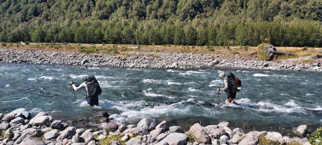
…then the Otehake River. In both cases, Oli and Matt went over first, dumped their packs and then helped Melly and I cross. Even after two days of dry weather, both rivers were flowing fast but thankfully it only got to knee deep.

Navigation from here became more difficult with marker poles becoming increasingly sporadic. The general vibe of the route was to stick to the true left bank of the river and not to cross it. Works for me, although I did wish the bank could’ve been less rocky. Occasionally a big orange arrow would guide us away from the waters edge and into the bush, it just so happens that the most common bush in these parts is gorse.
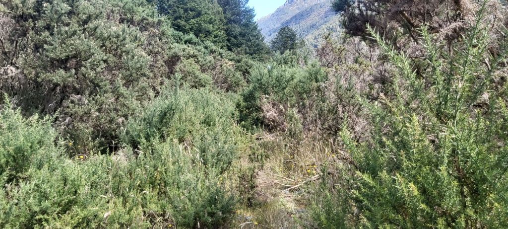
These bush paths were a welcome change from the rocky riverbed we were usually following, although I didn’t necessarily go any faster on them thanks to the arrival of many a friendly visitor.

Ah, we’ve now come to the part where I have to discuss the major event of today, which somewhat relates to one of these bush paths. The Taramakau feeds into the Otira River, with our trail turning left and heading upstream on the latter. To do so, we’re supposed to follow something called the Flood Track. Presumably it’s an all-weather access route to Morrison’s Footbridge. However, many of the comments I read on Far Out painted a poor picture of the trail, one even saying it had been designed by Satan himself. Their recommendation: follow the bank of the Otira. That’s what I suggested to the group and they decided to follow.
All went well at the start, it was easy to follow and there was plenty of room between us and the river. That room slowly shrank and we were soon forced onto the hillside. When that ran out, our options were to either cross the river, turn back, or find a way up the hill to the track we’d avoided in the first place. Oli, at the head of the group, thought he saw a route up and gave it a go. Route is being generous, getting up required the use of many a tree and loosed many a rock that the fully didn’t hit any of us. Once he was up and rid of his pack, he started coming back down to help us. In the meantime, Melly had started climbing too.
Then everything went wrong. Whether something snapped or the ground just gave out, Melly lost her footing and slid down the hillside, caught by Matt just behind her. Once she’d found a decent spot to stand up, she assessed the damage. A large gash was on her right leg. Matt jumped to action stations and began providing first aid. I helped out where I can, with water and a few first aid items of my own. Understandably she was in a great deal of pain and was shaken up by the fall. In hindsight we really should’ve turned around right then and there. But we didn’t, instead once she was patched up, Oli helped guide her up the cliff. Matt then followed, Oli coming back down to fetch me.
When I reached the spot where Melly fell, I fully understood how it happened. It was a face of loose soil with no good footholds at all. Patiently, Oli got me up it, I don’t know how. At one point he literally dragged me up to a tree by my pack alone. At the top, I lost it. This whole misadventure, in my eyes, had been my fault. I was the one to suggest taking the riverbed and my friends had trusted that decision. Look how that had turned out. I apologised profusely to Melly, still badly shaken up by the whole ordeal. This was inexcusable in my eyes, but she didn’t seem to think so. In her eyes, I was only following the feedback I found on Far Out which all spoke positively on going down the river. Presumably they’d done a couple crossings a long the way which we had hoped to avoid.
Once we’d had a moment to recover, we got started on the track we should’ve just taken in the first place. Yes, it was pretty janky in many places, but we got through it just fine. Being up higher also meant getting some nice views of the river we would’ve otherwise been on.
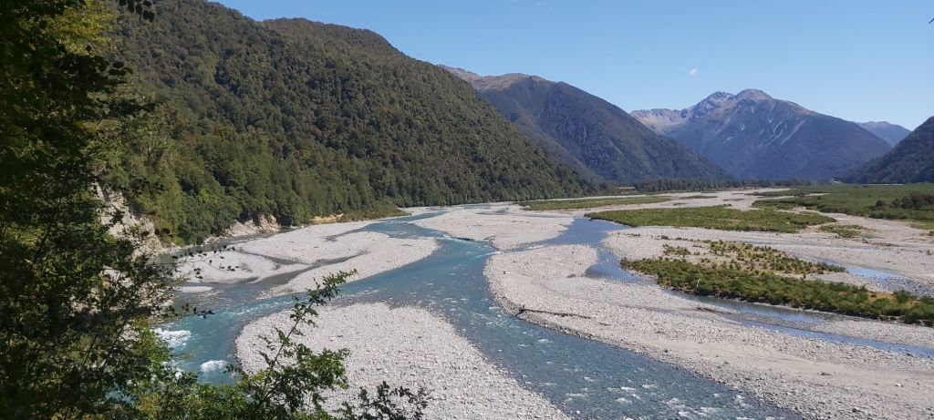
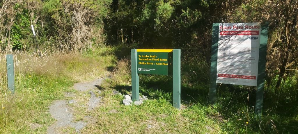
We reached the footbridge just after 5 pm and took a long break to recover from the whole ordeal. During lunch, we’d decided to press on for a couple more kilometres past the first two crossings of the Deception River which were supposed to be indicative of the current river level; if we can get through them, the rest should be fine. Just before 6pm we set off past one of DOC’s iconic green and yellow signs, although this one had a typo.
These first two crossings were indeed difficult but no more than what we had already done. A little while afterwards, with the sun already behind the mountains, we found a flat, grassy area and set up camp with a warm greeting from thousands of sandflies. Bravely I ate dinner in my tent and started to think about tomorrow’s walk up to Goat Pass. It’s going to be a long and tricky day with plenty more crossings of the Deception. At least the weather was looking nice so we shouldn’t get into any worse trouble than what we went through on what was a very eventful day.

Leave a comment