


Date: 21st January 2024
Start: West Sabine Hut (km 2007.3)
End: Waiau Hut (km 2030.8)
Distance Travelled: 23.5 km
Total Distance Completed: 1870.8 km
Song Currently Stuck in Head: Days Like These by Hillsong United
Views from Waiau Pass: indescribable
Hey ho, it’s time for another one of those days which I’m a bit scared to do but know I have to do it anyway. Based on the current forecast, this is the only day in the near future where the weather, in my opinion, will be good enough to cross Waiau Pass. I was hoping to start this day from Blue Lake Hut, but yesterday’s weather prevented that from happening. So, I’m starting 7 km further down the valley, forcing me to start early, leaving West Sabine Hut just before 7am. Melly left half an hour prior to give herself enough time to get the photos she wanted. Team Matt had also left earlier, knowing they would be slower than us. That just left Oli and I at the rear, starting our day by crossing a swingbridge and slowly climbing up the true left bank of the Sabine River.
I don’t know what Oli’s goals were for this section, but I wanted to reach Blue Lake within 3 hours so I knew I had to keep a decent pace regardless of what the track conditions were like. Through the forest it was alright, well graded with the odd root or rock to hop over, but as we ascended we reached the avalanche paths. Instead of a moist dirt track, we were back to rock hopping in the same manner as the trail up from Top Wairoa.

Nevertheless our pace was good, the trees soon giving way to alpine tussock fields as the valley walls closed in.

Nearing the hut we sighted our friends ahead of us, passing them with a kilometre to go. At the hut we were met by the volunteer warden who oddly asked to check our hut tickets from last night (there wasn’t a warden at West Sabine). She also asked us to fill in a survey about how we as TA hikers found the DOC facilities from Ship Cove down to here.
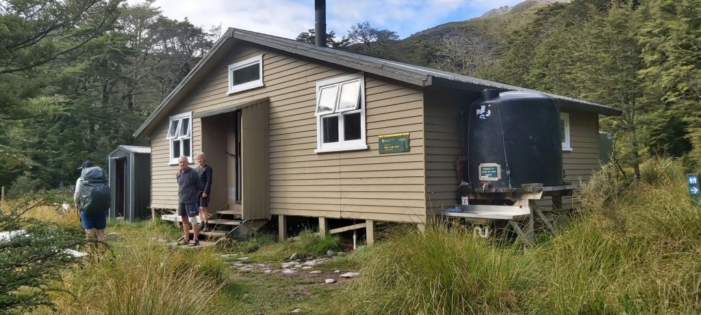
Team Matt and Melly arrived soon after but stuck around the hut a bit longer than us. For Team Matt, it was just the need to take a break before the pass, but for Melly it was due to condensation in her camera lens. With the promise of some of the best photo opportunities on trail, I can fully understand why she wanted to wait, but I had my concerns in both parties ability to reach the hut tonight. Oli and I left just after 10am and I had budgeted 9-10 hours to reach Waiau Hut. Any later and we’d be running out of daylight, so I half expected the others to pitch their tents somewhere prior to the hut.
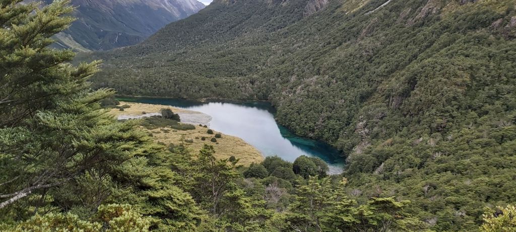
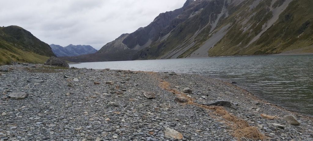
Now on a route, we aptly began by climbing up to Lake Constance, giving us some great views of the unworldly clear water of Blue Lake. If you’re ever up here, imagine yourself being a kid in an antique shop: look but don’t touch. The lake is tapu (sacred) to the local iwi (Maori tribe) and with the prevalence of an introduced algae in Lakes Rotoiti and Rotoroa downstream no one is allowed to touch/swim/wash in the lake. Just admire it from afar, because it’s incredibly beautiful.
We climbed up to the shore of Lake Constance (same rules as with Blue Lake) and then we climbed some more up a scree slope overlooking the lake. This was just the warm-up for the pass and already I’m getting tired.
As Oli says, what goes up must come down. “What” in this case being us as we descended back down to the shore of Lake Constance. Once down there, the track gets uncomfortably close to the lake, on a couple occasions skirting on rocks right on the bank where I can’t put my pole in the water to steady myself.
After the lake was the final 700 m of flat track we’d get today. It went by too fast, seeing the marker poles now heading up the steep slopes towards Waiau Pass, both dreading and psyching myself up for what’s to come.
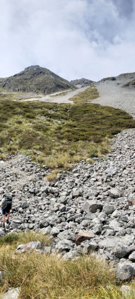
No gradual start to this climb, in an instant the track when from flat to steep climb, some places having a gradient of 1 in 2 (1 m up for every 2 m forward). The surface varied between muddy steps and scree, the latter of which was very annoying. I tried to kick in steps to help gain traction but it never worked. I don’t even want to think about what I looked like to anyone watching me stumble up the slope, grunting/yelling in frustration with every step. The only solace I could find was when I stopped, turned around, and looked from where I had come.

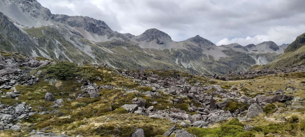
With less than 200 m to go, I reached a false summit and had the tiniest bit of flat walking before the final push to the pass. This time I could see the cairn marking the top and felt a second wave of determination to reach it. Still taking my time and pausing regularly, the scree on this final bit did offer me the traction I desired. With this new found grip, I began demanding more force from my calves to get past each remaining pole. 5 to go, then 4, then 3, then 2. I saw faces at the top waving down at me and as I crested the ridge at the final marker pole, I was greeted with what has to be up there with the best views I have ever seen.
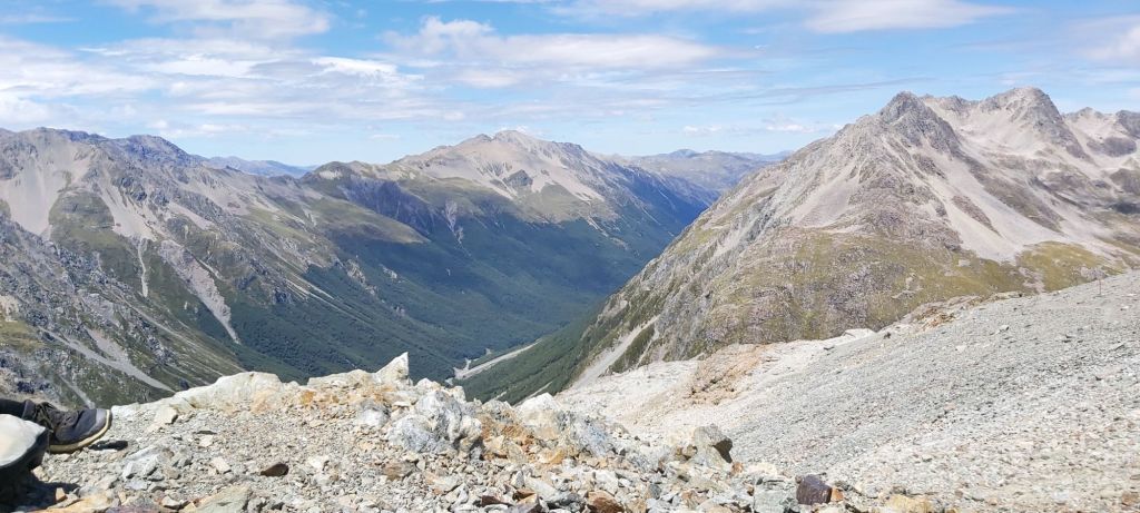

And this is why we pushed all the way to the pass today. The clouds had lifted high above us, letting our eyes see right down into the valleys on either side of us. The pass itself was very narrow (I guess this is what sets a pass apart from a saddle) but still with enough room for Oli, myself, and four other hikers to shelter behind some rocks for a well earned lunch break. If I wasn’t staring at my food, I was admiring the mountains, valleys, streams, and waterfalls around me and just thinking “how did I get here?” Not in the literal sense of I walked up here on my two feet, but in the events that led to me choosing to walk this trail that has taken me to this spot. What if Covid hadn’t happened? What if I hadn’t struggled with online uni? What if I had found a great job that started right after I graduated? All of these could have led me onto an alternative path away from Te Araroa. It makes me wonder if there is some more profound reason that I am out here. If the events in my life over the past few years led me to come out here, what influence will the trail have on my life in the years to come?
Before I had a complete existential crisis, I figured it’d be best to get off the exposed mountains; good weather never lasts long up here. Oli and I started down, easily at first but quickly finding ourselves in terrain better suited for mountaineering.
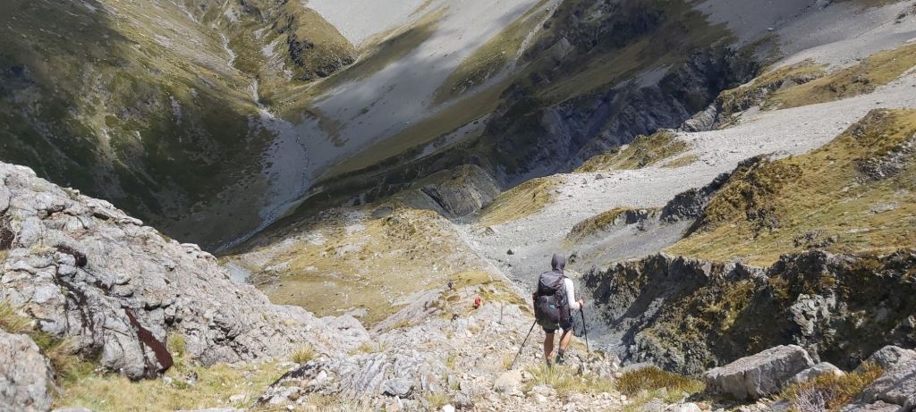
Steeply sloped but super grippy rocks stood between us and the valley floor. Oli was right at home and he spent a good amount of time helping to guide me down some of the larger faces. Because of his help and my recent experience in the Rintouls, I never felt scared despite the inherent danger and consequences if I did slip up. I just followed my tried and true strategy of taking my time with everything. Take a step down, stop, explore your options, pick the best looking route, think about what moves are required, execute them, and repeat. With each movement the valley floor and river flowing beneath it got closer and louder. It was thirsty work, a slight problem considering I’d run out of water I’m the ascent of the pass. Thankfully I came across a very clear pool of water halfway down that I didn’t have to bother filtering. Even thinking about that stream a day later is making me thirsty.

The jagged rocks ceased after this, but the steepness of the path did not. Still going slowly I kept descending, now following the bank of another super clean stream. I didn’t grab any water from this one, it was flowing awfully fast.

After managing to keep my feet dry all day, multiple river crossings down in the valley put an end to that streak. No worries, I was more excited by the flat path ahead of me. Finally, after two days of hard tramping over two steep mountain passes, I can finally open the taps and get some speed up. Through forest and field, Oli and I made quick work of the final 8 km to Waiau Hut.

With 3 km to go we passed by the site of the old Caroline Creek Bivvy, a 2 bunk hut that used to be the main accommodation for the TA after the pass before Waiau Hut was built in 2017. The site still makes for a good camping spot, currently occupied by some of the hikers we’d met on the pass. This was good news for us. We’d passed by a couple more hikers on our way down and based on the numbers at Blue Lake Hut last night it was now looking like there might be 1 or 2 beds free at the hut for us. With that boost of motivation, we darted down the path which was almost completely flat, arriving at the cute little hut 11 hours and 50 minutes after we left West Sabine.

There was one free bed, hastily nabbed by Oli. Fair enough, he’d earned it, I’m happy to sleep on the floor. Who were in the other beds? Most of them I didn’t know, but most surprising was the appearance of Destroyer! Through a mixture of many long days and little breaks in between I’d caught up with her, having last met all the way back in National Park.
That was sadly the last nice surprise of the day. At 7pm whilst eating dinner, I heard the unmistakable boom of thunder emanating from the pass. Or at least where the pass was, now covered in rain clouds. How quickly that had changed from the gorgeous weather we walked through mere hours ago. My thoughts turned to the whereabouts of Melly, Matt, and his dad. I knew they wanted to come all the way here but with no sign of them now I guessed they had found somewhere to camp after the pass. Hopefully they will endure the storm alright and we can meet with them at tomorrow’s hut. In the meantime, I need to sleep. It’s been a while since I did one of these long days on trail, they really take it out of you. Tomorrow looks to be much kinder on the body.

Leave a reply to Ramsey Southward Cancel reply