


Date: 14th November 2023
Start: Whananaki Holiday Park (km 322.2)
End: Pataua North Road (km 354.8)
Distance Travelled: 32.6 km
Total Distance Completed: 355.1 km
Song Currently Stuck in Head: The Path by Lorde
Hours on Trail: 11
I’m convinced Earth’s gravitational pull is stronger before sunrise. How else am I supposed to explain by apparent inability to rise from a horizontal to a vertical position in the morning? Today, I overcame this heavy weight, waking up at 5 and being on the move by 6:30, with frankly a lot of dread about what was to come during the day. At least it started alright, crossing over the longest footbridge in the Southern Hemisphere.
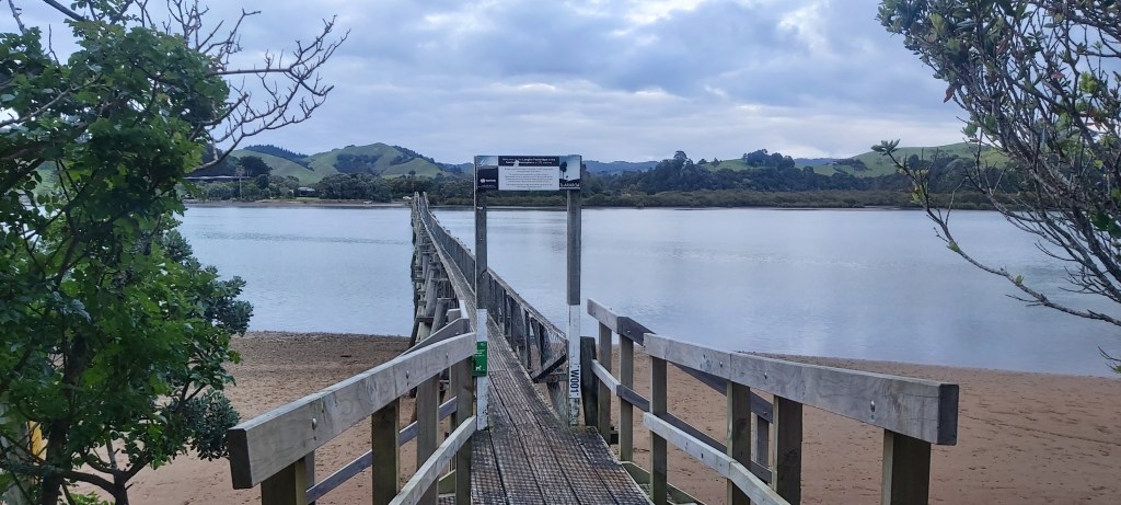
It was built to provide schoolkids from Whananaki South easy access to the school on the other side; beforehand they were reliant on a teacher fetching them in a rowboat. A short walk along the river bank led us towards a farm track skirting over cliffs in a way that reminded me of my time in the Great Ocean Walk, although the sea is a lot calmer here. For the most part, I walked most of today solo, each of us finding our own pace to travel at. Behind me were Melly and Matt, both if whom have very heavy packs due to all the camera gear they’re carrying (Matt has a freaking drone, for crying out loud!), with the rest of the group spaced out ahead of me. There wasn’t really a need to stick together, with no hazardous areas on this leg to Ngunguru.
There was one benefit to starting so early: some spectacular views looking towards the coast, even though it was an overcast morning.

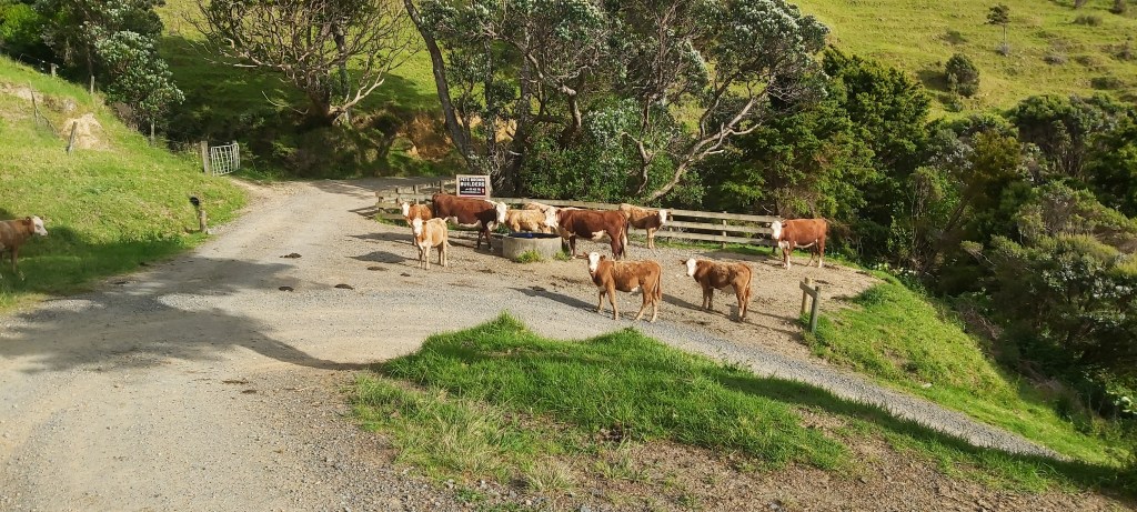
Although this is an advertised walking track that anyone can go on, there were constsnt reminders that it was still going through someone’s property, evidenced by the many cows I came across and the barking of dogs threatening me with a bad time if I did anything out of line. Then again, I was getting some ominous vibes from the cows too.
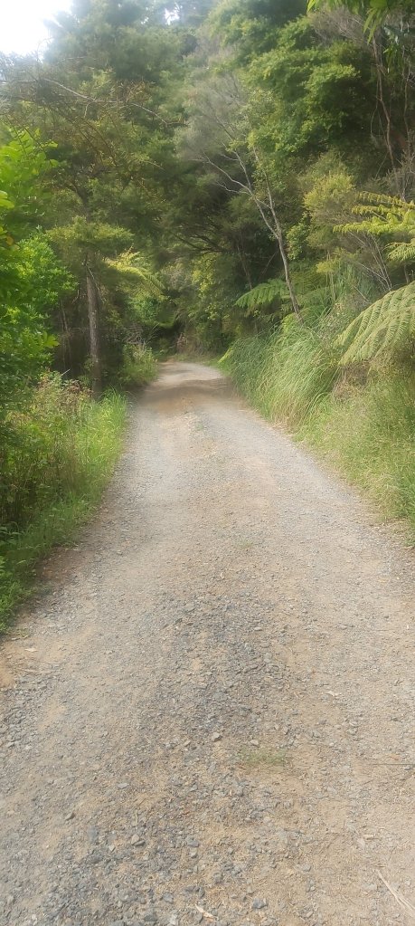
Unfortunately, this would be the last fun bit for a while, with the farm track leading onto a whole lot of road walking (this time I would actually walk it). The weather also started playing games with me, starting to rain and looking like it would get heavier – necessitating rain gear – only to ease off once all my gear was on, costing me around 5 minutes each time I had to put everything on and take it off again once I started overheating. The only highlight of this section was when I had my mandated 30 minute rest break. Otherwise it was very dull, hence the lack of photos.
Not to worry, it didn’t last forever. I then had to walk on more gravel roads!
If you can’t tell, the walk to Ngunguru was more draining than it was fun, the only fun bit coming from a Kereru sighting (love me some fat pigeons). I was also running into a problem where my upper right leg would start going slightly numb and then burst into an incredible amount of pain, like it was burning. I first noticed it on the Puketi Forest track and it’s happened a few times since then, often after a long road walk. I haven’t been able to work out what the problem is, but my running theory at the moment is that I’m doing up my hip belt too tightly and it’s restricting blood flow to my leg. Once I take my pack off, the pain goes away almost instantly (n.b.: my mum, who happens to be a physio, has just ruined that theory and believes it’s nerve-related).
Even with the added stoppages from the teasing rain and numb leg, I still managed to reach Ngunguru by 1pm, enough time to get lunch and resupply. Heading into today, I was hoping to get something healthy, like a piece of fruit and a salad. By midday I was very hungry, so that salad craving had turned into a burger craving, which then turned into a burger purchase and finally a burger eaten. Whilst waiting I also resupplied my food bag and once again was forced to buy a 5-pack of noodles. There’s only 2 days between me and the next proper supermarket in Ruakaka and I now had 7 days worth of food. I guess I wasn’t forced to buy noodles specifically, but it’s a hiking staple and I didn’t see any better options. At least I got a proper burger.
2 km further down the road, we hit the Ngunguru River. Matt notified James, the owner of Nikau Bay campsite, who came over in his tinny to pick us up. Not all at once, obviously, there were 7 of us after all (Lupi having joined us). 3 boat loads later and we were all across on the other side.

Nikau Bay campsite is famous and well loved among TA hikers, mostly thanks to James’ hospitality and knowledge of the local region. Although we weren’t staying here, he still gave us an in-depth briefing of the upcoming trail, particularly on the two river crossings we’d be doing over the next two days. I wasn’t particularly worried about the first one – the Horahora River – but the Taiharuru estuary we’d cross tomorrow had been on my mind a bit. It’s 3 km long and I’ve seen more than a few photos of walkers having to carry their packs on their heads. This briefing really helped put my mind at ease, telling us when we could cross, what the conditions in the river would be like, and how high we could expect the water to be. After a cameo from James’ dog, we said our goodbyes and left as one big group heading for the Horahora.

An hour later and we were there. James had told us to line up the red markers on either side of the river and cross between them. Off came the boots and on went the reef shoes, and into the water I went…

…and nothing really happened. The crossing was an absolute breeze. The river wasn’t flowing the strongly and it never got deeper than my knees. What had I been so afraid of? I was now brimming with confidence for the estuary crossing tomorrow; provided we do it at low tide, how much harder could it be?
Well, there was one final obstacle standing in between us and our camp for the night. The banks were lined with mangroves. There was a marker path through them, it just happens that this path is through thick, smelly, black mud.
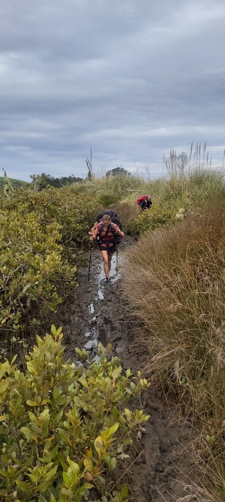
We had been warned about this, but it still was pretty gross to walk through. Once on the other side, we took some time to clean off our feet before heading off to Derek and Ann’s place, our lovely trail angels for the night. Their house is about 1.5 km along the bypass route and offers a great view over the river; apparently they had been watching us cross through a telescope. Upon arriving they showed us around and we got our tents set up in their backyard. There were more welcome surprises in store after dinner, when they provided us with apple and rhubarb crumble.

It was sublime and seemed to make all of the days challenges and discomforts drift away. With that said, mum, this is not a licence to start putting custard on things. The evening was spent sharing stories and having a yarn with our incredible hosts before we fell asleep to the sound of rain falling on our tents.

Leave a reply to jono southward Cancel reply