


Date: 23rd February 2024
Start: Careys Hut (km 2751.6)
End: Kiwi Burn Hut (km 2777.4)
Distance Travelled: 25.8 km
Total Distance Completed: 2623.9 km
Song Currently Stuck in Head: Cold Heart by PNAU, Elton John, and Dua Lipa
Brief Description of Today’s Trail: easy and flat with a small obstacle course
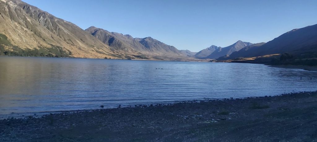
North Mavora Lake this morning was beautifully still. The sun was beginning to rise and shine on the mountains on the other side but wouldn’t hit the lake itself for a couple more hours. In other words, perfect conditions for a hike. That’s not even mentioning the flat 4WD track I’d be following for the first couple hours too.
Warmed up by walking, I settled into a steady rhythm and got a bit lost in my own thoughts as I followed the east bank of the lake. How should I react when I reach Bluff? What should I eat when I return to Brisbane? Where should I stay tonight? The last of these played on my mind the longest because I didn’t have a good answer for it. My original intentions were Kiwi Burn Hut, but I was then hoping to get out onto the road and walk/hitch my way to the start of the Takitimu Track. The only feasible way to do so would be to backtrack for 3 km to a swingbridge. Maybe I should just camp by the bridge? Or maybe I could cross the bridge today and try to get a hitch to Te Anau? That doesn’t sound too bad, heading into town for a good meal, shower, and all those nice things. For now I tried to set those thoughts aside as my eyes gazed upon the lake.
Nearing the campsite I had a choice to either follow the lake edge or take a forested path just beside it. I’m very glad I went with the latter because I ran into probably the tamest robin I’ve ever seen. With no hesitation he hopped over to my feet and started checking me out. I had time to burn so I sat down on a rock and let him do his thing. I didn’t get any photos of him or his shenanigans but I’ll see if I can give you guys a bit of an insight as to what was going through this little guy’s head.
“Hey, it’s another one of those giant wingless creatures that walks through my forest. I must go and say hi. Oh, it’s looking at me, it certainly is very tall. Say, are those sandflies buzzing around you? Why thank you sir! I was feeling a bit hungry. *snatches a couple sandflies out of the air* Hey, where are you going? And how did you suddenly make yourself shorter? You look a lot less scary now. Ooh, I can see more sandflies on those black legs of yours (I was wearing my leggings), maybe I could… *hops up onto my shoe and then onto my leg* There we go, now I can feast! *proceeds to eat about a dozen more sandflies* Thank you very much giant fatherless creature!”
I sat on that rock or a good 10 minutes just letting him do his thing. Having a wild animal approach you and then eat a the annoying parasites buzzing around you is a very special experience and one that I hope to not soon forget.
Shortly afterwards I arrived at the Mavora Lakes campsite, an expansive site with caravans and tents dotted about the place. Evidently any TA hikers who stayed here last night would’ve left a few hours ago.
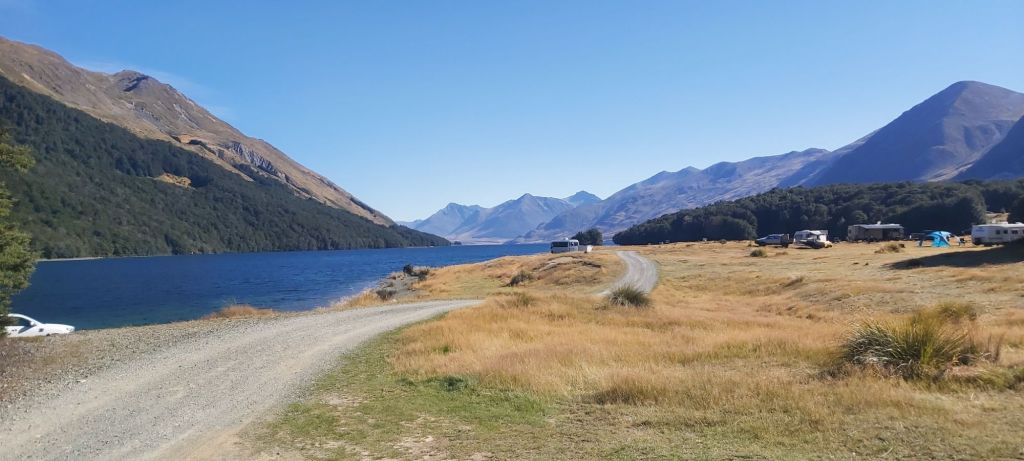
I can certainly see why it’d be a popular place to visit if you’re the sort of person who prefers camping with a bit more gear. I’ve got a few friends back home in Australia who love their car camping and I know would love to come to a place like this.
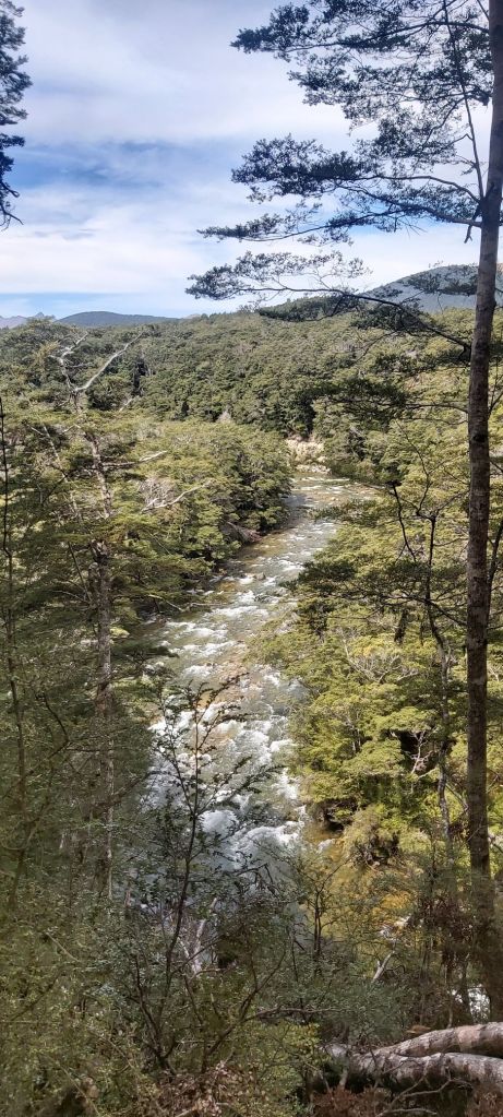
Still solo, I had a quick snack break here and then walked across a solid swingbridge onto the track to South Mavora Lake, a smaller but no less pretty lake just south (hence the name) of its big brother.

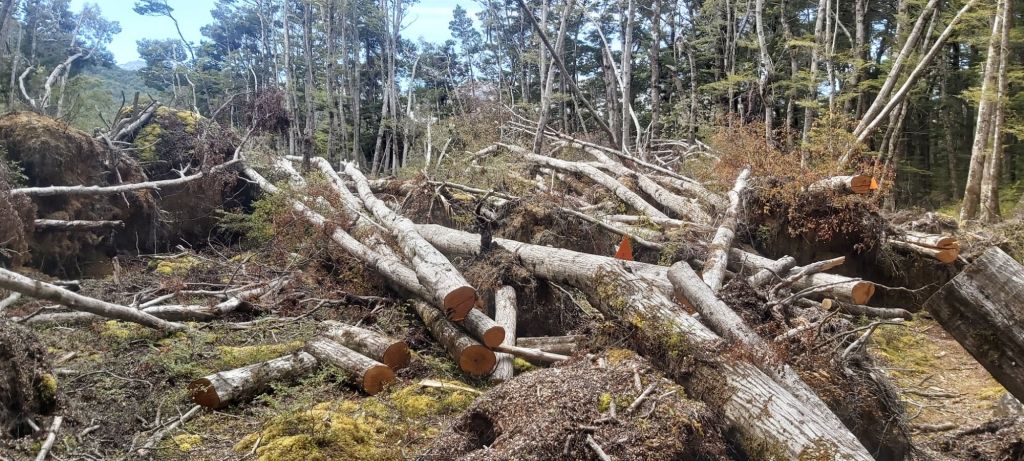
No longer on a 4WD track, I was expecting to be going a bit slower through this part, but the track ended up being to a very high standard. The main hazard along here was treefall. Evidently one or multiple storms in the past had blown down dozens of trees onto the track, however all of the big ones had been chainsawed and the path was remarkably clear, even if I could still see evidence of said storms all around me.
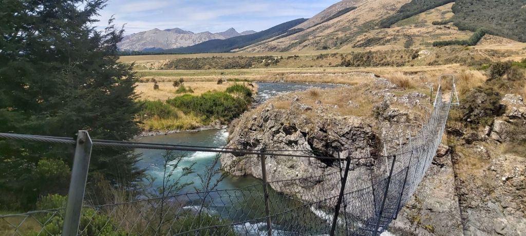
In very little time I was at the bottom of the southern lake and at another swingbridge, even more fancy than the one up north. I popped over the other side for lunch and to do some more thinking about where I should end my day. I’ll save you the ramblings going around my head, all you need to know is that my final decision was to reach the next swingbridge, head across to the road and try to hitchhike into Te Anau, and if that failed come back across into the forest and camp by the bridge to try again in the morning.
With that sorted, I got stuck into the path to Kiwi Burn, one that Far Out warned of more treefall that hadn’t been cleared by DOC yet. Some of those comments must’ve been a bit dated because for the first 3 km I encountered lots of chopped up trees and a super clear path through a lovely forest. After that point is a different story. As one commenter put it (shout out to Trailblazer Johnny), I had left the Mavora Walkway and entered the Mavora Obstacle Course.
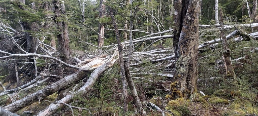
The next kilometre was covered in trees, forcing me to scramble over and under them as best as I could. To my surprise I ended up having a lot of fun working out how to get past each obstacle. I’d approach a tree, assess the best “path” to take, and the execute it. It was a fun little test of my problem solving skills and I got through the section faster than I anticipated.
Shortly after the obstacle courses was completed I reached the Kiwi Burn swingbridge. The TA continues south and fords the Mararoa River on foot, but this bridge acts as a bailout opportunity if you want to walk the road or in my case get a hitch. A quick check of the weather forecast confirmed that this was the best course of action, with plenty of rain due to come tomorrow. Across I went… well, across I tried. Halfway through a stray bit of chicken wire snagged my tent bag and tore a big hole in it. I was stuck fast on a flimsy swingbridge 10 metres above a deep, rushing river. Eventually I got myself free and assessed the damage on the other side. I arrived at a similar conclusion to Anatoly Dyatlov when he received a 3.6 roentgen dosimeter reading after Chernobyl Reactor Number 4 exploded: not great, not terrible (seriously, watch the Chernobyl miniseries done by HBO, it’s incredible). The tear wasn’t small but my tent wasn’t at risk of falling out, although I may have to request Matt’s sewing skills when we meet again.
Anyway, I’m now on the road and waiting for some cars to come past, hopefully with a kind and generous driver at the wheel. But no one came for a long time. When I eventually did see a dust cloud approaching, it was a truck. That became the pattern for the next hour; very little traffic, and the vehicles that did come past were clearly not in a position to pick up a hitchhiker. Dejected, I went back to the swingbridge and weighed up my options. I could camp here, or I could go to the hut. With no real desire to spend a night alone out in the forest, I decided to scrap my original plan and make the 3 km journey south to Kiwi Burn Hut. At least the track was nice so I could make excellent time down it. Rather annoyingly, right before I reached the hut I had to do a river crossing after keeping my feet dry all day. I guess this is the price I have to pay if I want to spend a night there. Hopefully the hut is nice?
It was, and the people inside the hut were even nicer. I’d caught up with Team Aotearoa (Alan, Boris, Janet, Rob, and Lily – yes I know she’s British but she’s been with this group for ages so I’m including her with them), all of whom seemed delighted to see me again. Best of all there were still free bunks to nab.

The hut layout is a main living quarters with fireplace and dining table flanked on both sides by a bunkroom with 6 beds in it. Works for me. Along with Team Aotearoa was another Kiwi walking NOBO named Chris, who also happened to be the first hiker I’ve come across to use the same Sea 2 Summit pot as me, and Callum. The only reason why I’ve caught up with him is because he’s been taking a bunch of side trips along the way, including a somewhat common bypass of Queenstown via the Cascade Saddle. He and I got talking about tomorrow’s walk. Neither of us felt like going down the official route which was described in the trail notes as being overgrown and lightly marked. With rain coming, I wanted to get as far down the trail as I could before it hits. Luckily, Callum had a plan for how to get to the road without the 3 km backtrack I’d been fearing. He had an app that showed a bunch of unmarked angler tracks from the road to the river that were classified as public rights of way by Fish & Game New Zealand. Anyone is allowed to use them to get over private land to reach waterways (although they’re usually not publicly advertised) and there was one only 500 m back up the trail, not 3 km. There’s a risk it’d be hard to find but that could save a tonne of time for me. Guess an early start is on the cards so I can go with Callum to this trail. Afterwards I’ll walk down the road still aiming to get a hitch, but this time only as far as the highway. There won’t be a trip to Te Anau anymore, I’ll be heading straight back onto trail. With that I went to bed…
…except as I began to doze off, I heard the unmistakable noise of people arriving at the hut. It’s 9:45pm, what are you doing here? I didn’t get up to ask but I could hear them making dinner in the main living area for sometime afterwards. Maybe I’ll get an answer in the morning.

Leave a comment