

Date: 3rd February 2024
Start: Rakaia River (km 2275.5)
End: Comyns Hut (km 2291.5)
Distance Travelled: 16 km
Total Distance Completed: 2129.2 km
Song Currently Stuck in Head: Stayin’ Alive by the Bee Gees
Weather: sunny or hailing, take your pick
Has anyone ever noticed how great a normal bed is? Because they’re pretty great. And if you disagree, go sleep on a combination of air mattresses and DOC hut mattresses for a month, then come back to your normal bed. They’re not terrible, but they don’t come close to the real thing.
Before this turns into an unintentional ad for some mattress company, let’s talk about the events of today. A very relaxed morning brought in the start of the day because our shuttle around to the other side of the Rakaia River wasn’t coming until 11:30. Outside was also pretty cold so I was more than happy to stay in bed for a bit longer than usual. When I did get up and head over to the lodge, I was greeted by Allison and Andy who offered me coffee. For the next couple hours I got talking with some of their friends about the trail and life back on the West Island. Sadly I had to get packing as Alec from Methven Shuttles arrived.
It was a 45 minute drive to Methven where we reunited with Melly, resupplied at the Four Square, and got lunch at a burger joint to satisfy the constant cravings of hiker hunger. A few other hikers joined us for the journey out to the trailhead; Melly would go with Sean a bit later. The unsealed road was a bit rough to go over, but in just under an hour we had arrived. Oli and I said goodbye to Matt as he wanted to do photographer things. Namely, fly his drone over Rakaia’s braids at sunset. Pretty sure I’ve mentioned it already, but in case I haven’t, DO NOT WALK ACROSS THE RAKAIA RIVER! Ignore all the comments on Far Out explaining how some people foolishly did it. They got lucky. It’s a long way across and in a very short amount of time, the river can cut you off without any warning, even on a fine day. Just take the shuttle around or hitchhike if it’s possible.

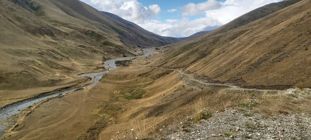
Now that I’ve got that PSA out of the way, let’s talk about the actual trail. It first goes through a hilly paddock with cows grazing along the banks of a stream. The little bit of fine weather we’d got in the morning as coming to a dark end. But, it never rained on us. Granted we did get some hail, only a centimetre in diameter.

It didn’t last long thankfully, with the sun coming out again as we climbed up to Turtons Saddle via… hang on this can’t be right… more switchbacks? For the second section in a row, we’re going up switchbacks? Nah, this is getting a bit too American for me, where’s the classic Kiwi “if the mountain says I should go up, then I shall” mentality to track design? Ok, maybe they’re onto somethin, as the climb was much more enjoyable than some of the more direct approaches I’ve been on.

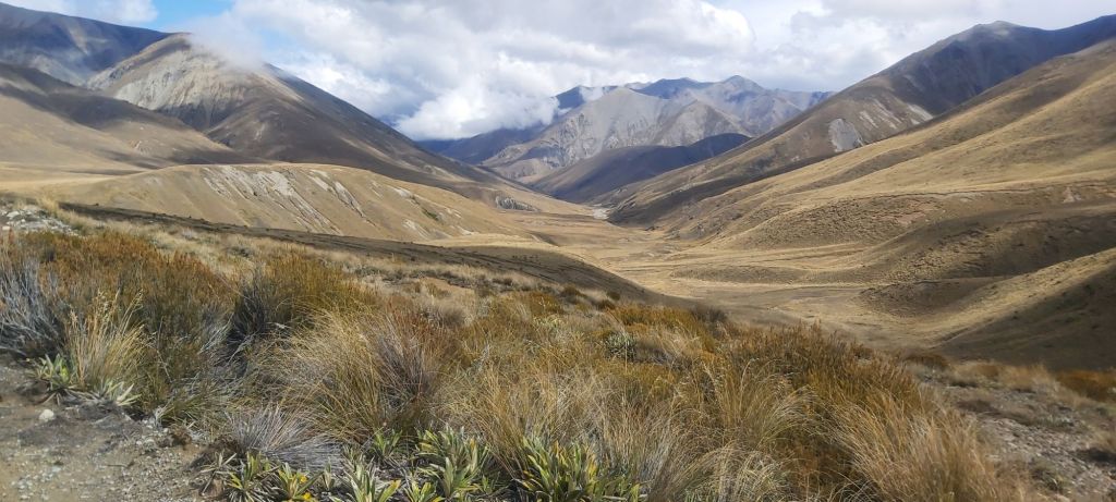
The sun stayed out as we crested the saddle and looked back down at the darkened valley below us.

Looking ahead, we could see that we were heading right into the depths of some of the finest Canterbury High Country out there. Not a tree in sight, just windswept hills covered in tussock overlooking jagged mountain peaks, the highest ones still containing a bit of snow on top. Remarkably different to the terrain further north.
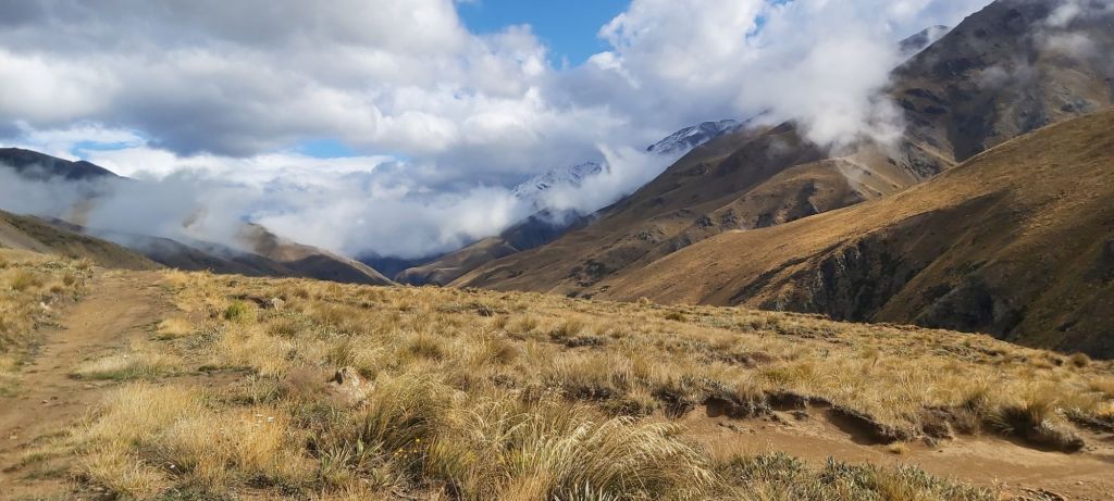
Descending into the valley, Oli shared some of his favourite anecdotes from his time serving in the Swiss Army (they have compulsory military service), arriving at the cosy A Frame Hut with impending rain clouds building on the horizon.

It was just a bigger version of the A frame I stayed in at Lagoon Saddle; this one actually had bunks. As soon as we left the rain hit, and this time it was rain, along with the unhindered wind blowing right into our faces. There won’t be any storytelling on this leg, it was time to get our heads down and our (very cold) feet moving. Oh yes, it was cold, and not due to any stream crossings, just pure air temperature and wind chill. It did not bode well for tonight. The pain didn’t last forever, eventually the sun showed its face again despite the late hour, now past 6pm.
All this time we’d been following a nicely graded 4WD track on what used to be a massive sheep station but was converted into a conservation park in the late 2000s. This track is a remnant of that time, now used for recreational purposes. More history can be seen in the huts in these parts. They were built long ago for musterers, retaining a lot of the character they’ve built up over the years. Comyns Hut is no exception, constructed from corrugated iron with a spartan interior. 8 bunks had been shoved into the back walls (all occupied by the time we arrived), a table stood in the middle of the room, and an open fireplace (sans firewood) was at the opposite end.
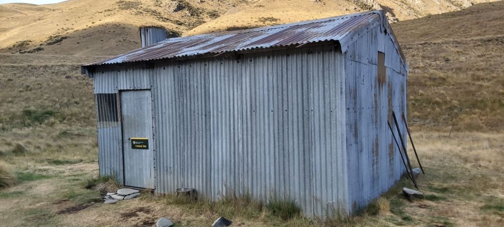
Two windows did their best to offer some light inside the hut, but it was pretty dark even at this hour. When all was said and done, there were 12 people sleeping in this hut, one of whom happened to be an old trail friend, Will (last seen in Paihia). For the sake of the rest of the hut, I quickly made dinner and got to bed, the rain having eased off but the wind stuck around. Tonight was going to be cold, especially being on the floor of the hut. I layered up, got into my sleeping bag, exposed the barest minimum of skin possible (i.e.: my nose), and braced myself for a cold night.

Leave a comment