


Date: 11th November 2023
Start: Peppertree Lodge, Paihia (km 244.7)
End: The Farm (km 281.2)
Distance Travelled: 25.6 km walked + 10.9 km by taxi (36.5 km total)
Total Distance Completed: 274.6 km
Song Currently Stuck in Head: Dancing Queen by ABBA
ABBA Vibes: immaculate
I have often said that I’m really not a morning person. However, if I’m given the right motivation, I can be ready to go at any hour. Today was one of those days. I have a long way to go today, so I was packed and checked out of the hostel by 7:15. As soon as I stepped on the road, Tom, Lupi, and Melly happened to be walking past on the opposite side. Our plan was to walk along the coast to Opua where we’d pick up a taxi at 9am which would take us around to Waikare. According to the trail notes and maps, this section is supposed to be kayaked, however this can only be done at high tide and it costs $100 per person. As such, it’s not an option that is taken up by many hikers. The typical alternative is to get a ferry across to Okiato from Opua and road walk until it meets the proper track. That was my plan until Lupi proposed the taxi last night.
So, we got going, making our way down to the beach with marks the trail at low tide. Just one small problem with that…

What would’ve likely been a simple beach walk turned into a mad scramble on narrow rock ledges. Moreover, it now put our 9 am arrival in jeopardy. It also didn’t help that the nice, paved pathway I assumed was in between Paihia and Opua was actually just a decent unpaved hiking trail with a lot of short but sharp ascents and descents. With that said, because it hugged the coast the views we got of the Bay of Islands were amazing.

We ended up getting into Opua around 9:10, but thankfully our driver was chill. Joining the four of us was Matt who I presume left earlier than us or took some other method to get here. The road to Waikare started alright but devolved into a windy gravel road that was very slow going. It took about 40 minutes to reach the end point for the kayaking segment.

We all set off at our own paces and I quickly found myself reaching the front of the group. I didn’t think I was moving particularly fast nor that everyone else was going slowly, I guess I’m just more comfortable moving at a quicker pace. Knowing there wouldn’t be a great deal of interesting sights on today’s walk (it’s all on roads), the earphones went in, the podcasts got turned on, and off I went. I debated hitching, but there was barely any traffic and I was feeling good. Also, I got a feeling that these roads were a bit on the dangerous side.
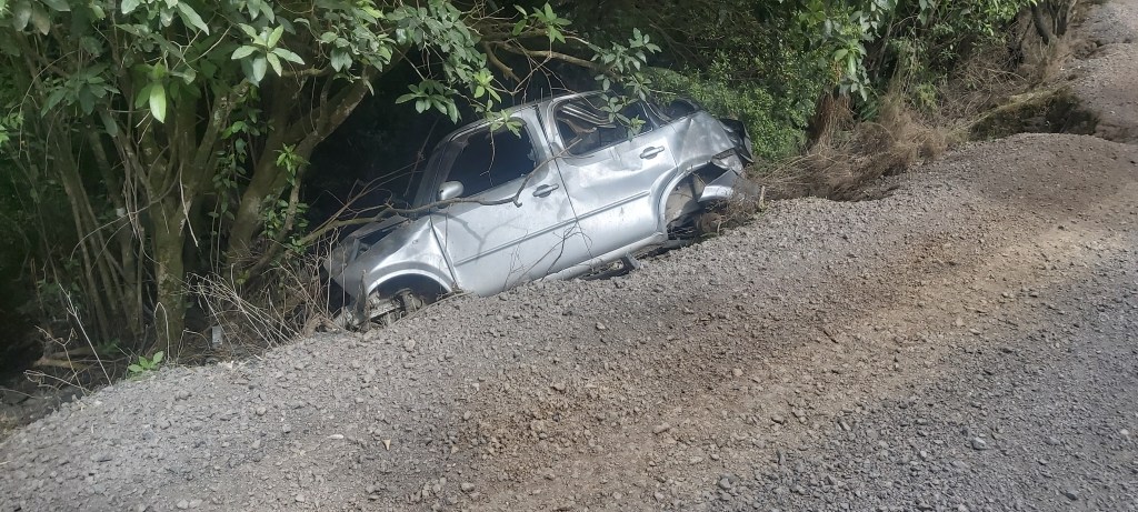
This was the first of three car wrecks I saw off the side of the road today. Hopefully the occupants got out just fine. An uneventful 6 km later led me onto the main road coming from Russell, at which point I made a colossal mistake. See, the trail only goes on this road for about 1 km before turning off onto a gravel road through Russell Forest (there used to be an actual trail through this forest until kauri dieback was found in the area). When I reached this turn-off, I saw two signs pointing down the road with big CLOSED signs below them. Me, thinking this was referring to the old route, kept going on the paved road for another 1.5 km.

What I failed to see was a bright orange arrow pointing down this road.

So, back I went having now added 3 km onto the day’s walk (not included in the distance mentioned at the top of the page). Feeling rather silly and a bit frustrated at this mistake, I had no choice but to press on, remaining patient all the while and ensuring I didn’t risk exacerbating my sickness or the health of my feet. About an hour later, after steadily climbing almost all the way, I stopped for lunch, as always taking off my boots and letting my feet breathe. The more I think about it, the more I’m considering mailing my boots down to Palmerston North and picking up a pair of trail runners in Auckland. When I’m hiking in mountains or rough terrain, I’ve found that my boots perform really well, but they’re pretty rubbish on these long road sections. I’d much prefer having some lighter footwear for these bits, which there’s going to be a lot of in the North Island. I’ll think about it further as I get closer to the big smoke.
Most of the time, the road was surrounded by hillside and trees. On occasion a gap would appear, providing some great views down into the secluded bays of the east coast.

After lunch I decided to take a break from listening to podcasts, instead choosing to indulge in some ABBA. It was a good choice. ABBA is always a good choice.
But do you know what else is good? A (literal) sign of progress!

Yet again, not much happened on the descent out of the forest. I passed Matt and Tom who were a bit puzzled at how I’d ended up behind them, along with catching up to Melly on the final stretch to The Farm. From where we got dropped off to here was about 19.5 km, which we began just before 10 and arrived at 3:30. And that was with a 3 km detour. For me, I like arriving at camp in the mid-afternoon, as it gives me more time to truly relax instead of frantically setting up my tent and eat long before sunset. Lupi was already here and to my surprise so was Jonas and Stella from Team France. Like many of us, they were nursing sore feet (in the form of a swollen Achilles) so they’ve taken two short days to reach here. Once settled it, I tried taking a shower, but the water pressure was so abysmal I gave up. Guess I’ll be stinky for a couple more days. Apart from that, there’s not much to speak of. It was just one of those days where nothing much happens. Still good to be out here doing this sort of thing though.

Leave a comment